OSINT & GEOINT Challenge Write-Up: Florida Snow
Bu çözümün Türkçesi de var: sağ üstten dili TR yapın.
- Challenge Author: Frank Diepmaat
- Task: Geolocate an illicit maritime drop-off point used by the cartel group “Los Aztecas”.
- Input Materials: Mission brief PDF, satellite aerial imagery (
starting-image-florida-snow.png). - Flag Format:
country-city-streetname
1. Initial Briefing & Tactical Scope
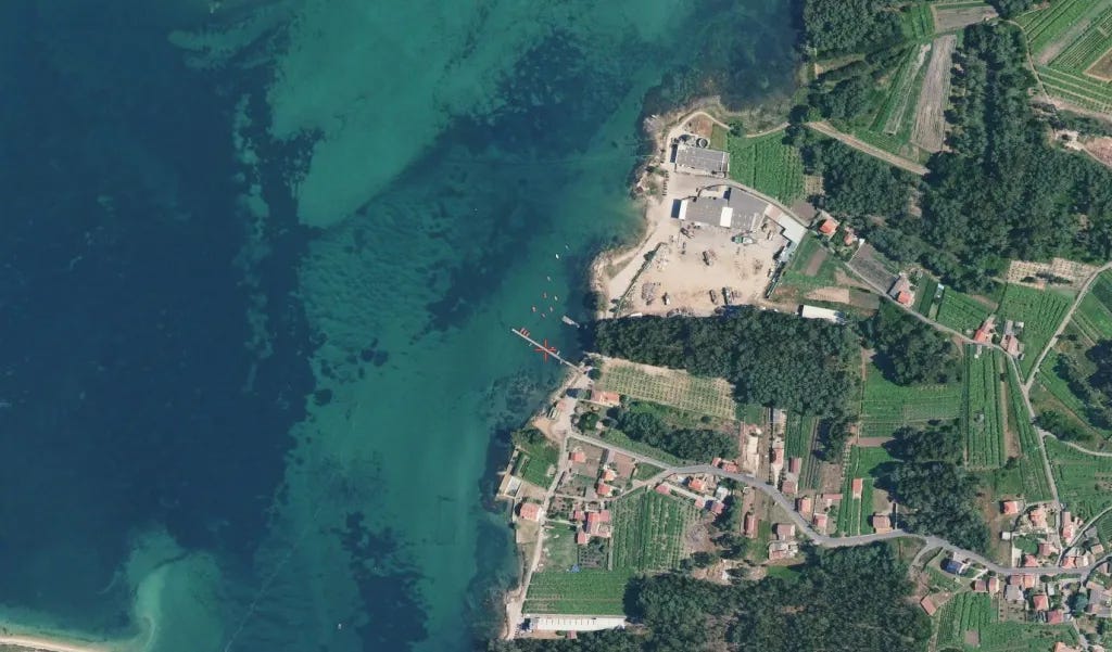
The DEA briefing outlined that a cartel network (”Los Aztecas”) was smuggling cocaine shipments by sea from Florida into Spain or France. The informant delivered an aerial surveillance image marking the drop-off jetty with a red cross.
2. Satellite Image Breakdown & First Deductions
A. Coastline Orientation (Determining East vs. West Shore)
- Orthophotos and aerial imagery defaults adhere to a North-up orientation unless rotated.
- In the surveillance photo, open water dominates the left side (West), while landmass, residential plots, and access roads are situated on the right side (East).
- This single observation immediately eliminates any eastern-facing coastline (such as the Mediterranean coast of Spain, where water would be on the right side/East). The target had to be a west-facing shore or the eastern interior bank of an inlet.
B. Biogeographical Clues & Green Spain (España Verde)
- The vegetation is intensely lush, dense, and deep emerald green, showing heavy annual precipitation.
- This rules out the arid, sun-scorched, Mediterranean-style topography of southern Spain (Andalusia/Cádiz) or dry French Mediterranean lagoons, strongly pointing to the Atlantic rim: specifically Galicia (Northwestern Spain) or Brittany (France).
C. Transatlantic Smuggling Route Context
- Transatlantic drug runs departing from Florida naturally strike the Iberian Peninsula from the west. Historically and operationally, the deep, fjord-like inlets (rías) of Galicia (particularly the Rías Baixas) serve as Europe’s primary maritime cocaine funnel.
D. Micro-Features in the Target Frame
- Pergola Trellis Vineyards (Parras): The agricultural parcels adjacent to the coast display an unmistakable grid-like pattern. This corresponds to the traditional Galician parra / emparrado system used for Albariño grapes to prevent fungal root rot from humid soil.
- Marine Depuradora / Aquaculture Hatchery: North of the jetty sits a commercial industrial hangar accompanied by round storage/filtration tanks and an open boatyard, typical of Galician mussel and shellfish processing facilities (depuradoras de marisco).
- Sand Spit / Barrier Bar: A thin, curved sand spit is visible in the lower-left corner, showing that this pier does not face the open breaking ocean waves, but rather a protected inner bay/estuary.
3. False Lead & Course Correction (The Initial Mistake)
- The Mistake:
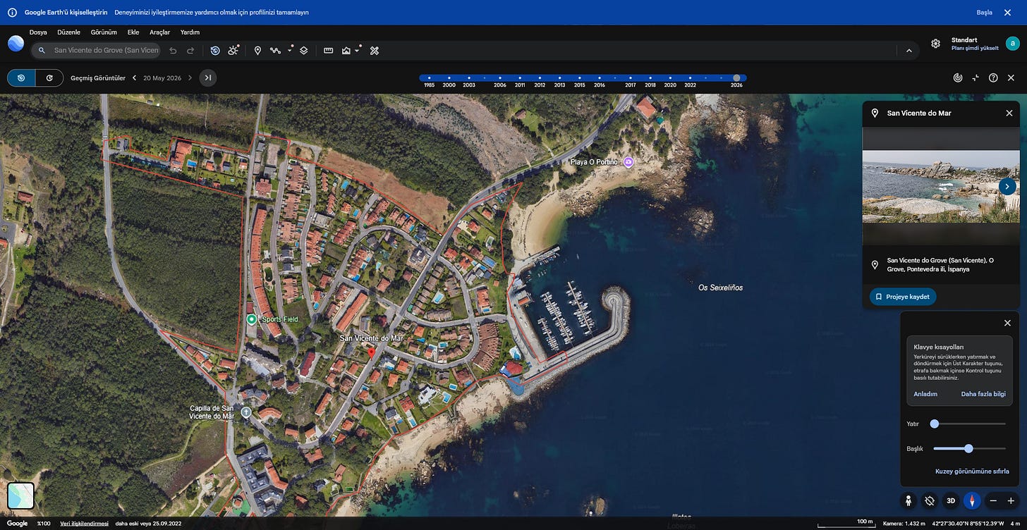
Based on the presence of Galician shellfish facilities and an initial broad sweep of the Salnés peninsula, the search prematurely landed on the southwestern tip of the O Grove peninsula (near San Vicente do Grove / Punta do Portiño).
- Why It Was Wrong:
- The coastline at San Vicente faces south/southwest toward open open-sea Atlantic rocky formations (Laxes, Ilotes).
- The satellite photo showed a calm, shallow inlet with inland sand spits and dense terraced vineyards right by the water, whereas San Vicente exhibited rocky headlands and coastal camping/tourist infrastructure.
- The Correction:
Recognizing the mismatch in coastal morphology led back to the drawing board: moving off the outer oceanic cape and focusing on the sheltered eastern interior shores of Ría de Arousa (specifically around Cambados and the Umia River inlet).
4. Reverse Image Search Limitations
- Attempting automated reverse image searches (Google Lens, Yandex Visual Search) on the raw aerial tile yielded no direct matches due to differences in satellite ingestion dates, water glare, and resolution variations.
- This emphasized the necessity of manual coastal corridor geofencing along the O Grove → Cambados → Vilanova de Arousa shoreline.
5. Pinpointing Ground Truth & Verification
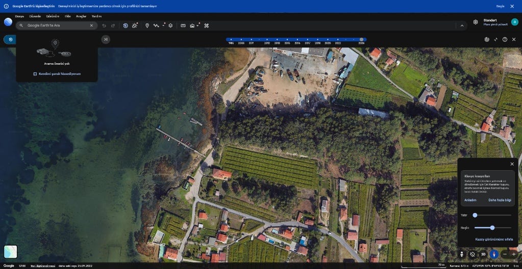
Tracing the eastern interior shoreline of Ría de Arousa directly south of Cambados revealed the exact structural footprint:
- Coordinates:
42°29'10.5"N, 8°49'31.2"W - Geographic Entity: Aldea o Facho, Cambados, Pontevedra, Galicia, Spain
- Ground Landmarks Matching the Frame:
- Pier / Jetty extending into the cove at Praia do Con de Sido.
- Commercial facility complex: AROUSA MARINE and Jobomar. O Facho directly north of the jetty.
- The sweeping sand spit to the south: Ensenada do Umia-O Grove intertidal sand flats.
6. Password Construction & Flag Submission
Following the mandated syntax:
country-city-streetname
- Country:
spain - City:
cambados - Street Name:
aldea-o-facho
Decryption Key / Flag:
spain-cambados-aldea-o-fachoOriginally published on Substack